วันอาทิตย์ที่ 26 มิถุนายน พ.ศ. 2554
TRMM- links
http://www.eorc.jaxa.jp/TRMM/typhoons/top_e.html trmm jaxa potral
http://sharaku.eorc.jaxa.jp/trmm/RT/index_e.html trmm hourly
http://sharaku.eorc.jaxa.jp/GSMaP/ gsmap
http://mirador.gsfc.nasa.gov/cgi-bin/mirador/presentNavigation.pl?tree=project&&dataGroup=Gridded&project=TRMM&dataset=3B42:%203-Hour%200.25%20x%200.25%20degree%20merged%20TRMM%20and%20other%20satellite%20estimates&version=006&CGISESSID=26e2583ae07e2b712d6c5ba4c6178743 trmm vary version
http://sharaku.eorc.jaxa.jp/cgi-bin/trmm/prnrt.cgi?code=game&lang=e pr near real tinme images
http://disc.sci.gsfc.nasa.gov/precipitation/documentation/TRMM_README/TRMM_3B42_readme.shtml trmm 3B42 by grad giovanni
http://www.eorc.jaxa.jp/TRMM/data/monitoring/day_pr/index_e.html trmm pr hourly rainrate
CAPPI-RADAR
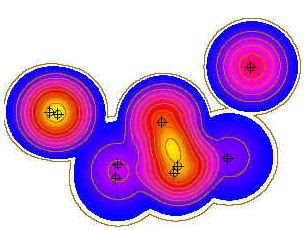
psuedo CAPPI- using highest elevation to fill an area nearby radar that doesn't reach the specified CAPPI height and far range filled buy lowest elevation.
read basic=> ftp://ftp.sigmet.com/outgoing/manuals/irisug/24cappi.pdf
CAPPI: constant altitude plane positinon indicator
1.convert 3d spherical coordinates to 3d cartesian coordinates
x=rsin(theta)cos(omega)
y=rsin(theta)sin(omega)
z=rcos(theta)
*theta=elevation angle of radar
*omega=azimuth angle of radar
2.define height to be interpolated to CAPPI plane
3.Calculate a weight factor from a group of radar points to a considering new grid by within a given distance by nearest criteria.
while you will know the weight factor, calculate the radar values of the points within radius based on weight factor.
4.Insert the calculated radar point to its corresponding caratesian 3dgrid (x,y,fixed Z).
Do until finishing computation all of radar grid.
วันพุธที่ 22 มิถุนายน พ.ศ. 2554
Calculate distance, bearing and more between Latitude/Longitude points
บางครั้งจำเป็นต้องแปลงค่าพิกัดจากอีกระบบหนึ่งไปสู่ระบบหนึ่ง ถ้าหากมีตัวอย่างโค้ดก็คงจะมีไอเดียมากขึ้น ดูได้จาก
"Movable Type Scripts"
วันอาทิตย์ที่ 12 มิถุนายน พ.ศ. 2554
ฐานข้อมูลเหตุการณ์รุนแรงทางธรรมชาติทางภูมิอากาศของNOAA
หน่วยงาน NCDC ของ NOAA ได้จัดทำฐานข้อมูลภัยธรรมชาติที่รุนแรงที่เกี่ยวกับภูมิอากาศไว้เป็นอย่างดี มีทั้งรายงาน สถิติ แผนที่ ไดอะแกรม ตามพื้นที่และเวลา เข้าไปหาข้อมูลได้ "เวบไซต์ฐานข้อมูลNCDC"
เวปแมพ extreme events
เหตุการณ์รุนแรงทางธรรมชาติที่เกี่ยวกับภูมิอากาศ มีด้วยกันหลายประเภท ได้แก่ อุทกภัย ภัยแล้ง ดินถล่ม พายุ ทาง NOAA ได้จัดทำฐานข้อมูลภัยพิบัติทางธรรมชาติที่รุนแรง ออกมาเป็นรูปแบบแผนที่ออนไลน์ เข้าไปดูได้ครับ "extreme event web map by NOAA"
วันศุกร์ที่ 10 มิถุนายน พ.ศ. 2554
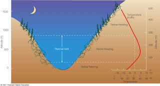
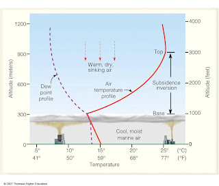
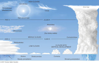
เอกสารการเรียนรู้อุตุนิยมวิทยาเบื้องต้นของ vermont state college
เข้าไปอ่านได้ที่เวบไซต์ .Lyndon State College Atmospheric Sciences.
มีหลายเรื่องที่น่าสนใจเช่น Atmospheric Stability , Thermal belt
Cloud Development
วันพฤหัสบดีที่ 9 มิถุนายน พ.ศ. 2554
โปรแกรม Grads เพื่อการวิเคราะห์ข้อมูลภูมิอากาศ
ข้อมูลภูมิอากาศ จำเป็นที่จะต้องถูกแสดงผลอย่างถูกต้อง เพื่อประโยชน์ต่อการวิเคราะห์ ไม่ว่าจะเป็นในรูปแผนที่ กราฟ โมเดล และต้องหาระบบที่ง่ายต่อการใช้งาน ที่มีทั้งคู่มือ เวบบอร์ด
Grads เป็นโปรแกรมที่ง่ายต่อผู้เริ่มต้นเรียนรู้ อีกทังมีผู้ใช้มากมาย สามารถสืบค้นข้อสงสัยต่างๆในอินเตอร์เนตได้ง่ายเมื่อติดปัญหา
ลองเข้าไปเรียนรู้เบื้องต้นได้ ที่ลิงค์นี้นะครับ "Grads tutorial"
วันอังคารที่ 7 มิถุนายน พ.ศ. 2554
check topology arcgis before you doing geodatabase
ก่อนทำ geodatabase ต้องยุ่งเกี่ยวกับการวางแผน Topology setting
arccatalog->Cluster tolorance, Ranks, Topology rules, validate topology
อ่านเอกสาร whitepaper ของ Arcgis ได้ตามตามลิงค์นะครับ "Topology setting"
แนวคิด Topology ของ ESRI "Topology concept"
หรือจะเข้าไปดูบล๊อก "Topology and Layers in GIS" เป็นบล๊อกของคนที่ชื่อ Rashid's
วันจันทร์ที่ 6 มิถุนายน พ.ศ. 2554
แบบเรียนเรดาห์จาก NOAA online ดีที่สุดแต่ตั้งมีมา
วันเสาร์ที่ 4 มิถุนายน พ.ศ. 2554
วันศุกร์ที่ 3 มิถุนายน พ.ศ. 2554
วันพุธที่ 1 มิถุนายน พ.ศ. 2554
library and radar tools NOAA
http://www.ncdc.noaa.gov/oa/radar/radardata.html#DOWNLOAD
Decode Radar Data
Decode Radar Data
Real-Time Radar Data
Storm Events Database
Radar Data Access
Download Data From NCDC Archive
สมัครสมาชิก:
บทความ (Atom)